Anilao,
a small baranggay in Mabini, located at the west of
Batangas, is a close diving site to Manila. This made
it a famous spot for day and weekend trips for diving
and for other sea sports. It offers the best-known
diving in the Philippines.
Most of the early diving camps nowadays are holiday-camp-style
water sports resorts. Some really specialize in diving,
others offer the same with other different water sport
activities. Many of the dive camps are situated along
the coast of Balayan Point. Some do not have access
by road, so, to complete the last part of the journey
by banca from Anilao.
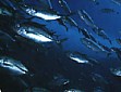
The
diving sites in Anilao are mostly gentle slopes with
coral patches that go with some
huge rock formations and small walls. All the reefs
are excellent for sea stars, sea cucumbers, and other
colorful fishes. Pelagic creatures can be found around
the offshore reefs.
In
some of the open-water areas, most of the dives can
have some fierce currents. Divers, experts or beginners
should check the tide tables.
Diving is good all year round, the best season being
November till May.
Ligpo
Island Location. Located
west of Ligpo Point Access. 40 min N by banca Average
Depth. 90ft Maximum Depth. 200ft Conditions.
Calm but can have some very strong currents that change
quickly. for experienced divers when currents are
running with visibility up to 80ft.
This island can be circumnavigated on one dive, but
you may have to seek shelter from the current. The
eastern (shoreward) side has all the reef fishes,
but when the current is running various pelagic species
can be seen out of the depths. This is a good night
dive at
neap tides.
The Cathedral Location.
Located just off Bagalangit Point Access. 5 min by banca south along the west
coast of the Calumpan Peninsula. Average
Depth. 90ft Maximum Depth. 200ft Conditions.
Calm but can have some strong currents that make photography
difficult with visibility up to 80ft. The site is
best dived at neap tide.
This is a Marine Park Sanctuary and probably the
best known Philippine dive site. You can swim to this
spot in about 6-10 minutes depending on the current
direction. Then you swim down a little more across
sand with small coral heads, soon to be met by hordes
of fish. When the current is running there are colorful
feather stars and inflated soft corals everywhere.
Eagle
Point Location.
Located west of Eagle Point, south of the Cathedral Access. 7 min by banca south along the west
coast of the Calumpan Peninsula. Average
Depth. 33ft Maximum Depth. 60ft Conditions.
Generally calm with a gentle current with visibility
can reach 65ft.
This is an easy dive with a shallow drop-off from
25ft to 60ft. There are plenty of small reef fish,
sponges, nudibranchs and feather stars.
Koala Location.
Located South of Eagle Point. Access. 10 min by banca Average
Depth. 60ft Maximum Depth. 80ft Conditions.
Generally calm with a medium current with visibility
up to 65ft.
Koala is a good dive for novices with soft corals,
some big boulders, small reef fish and anemones with
clownfish.
Dead
Point Location.
Located off the small point south of Koala. Access. 8-10 min south by boat from EAGLE POINT
pier Average
Depth. 33ft Maximum Depth. 70ft Conditions.
Calm with little current which can get up to medium
with a visibility up to 65ft.
Offers small coral heads on sand, plenty of small
reef fish, sponges, feather stars, soft corals, hydroids
and anemones with clownfish.
Twin
Rocks Location.
Located southeast of Twin Rocks Access. 25min by banca Average
Depth. 6m (20ft) Maximum Depth. 12m (40ft) Conditions.
Calm with just a slight current with visibility up
to 65ft.
A gradual slope
with sponges, algae, hydroids, feather starts and
small reef fish, sometimes shoals of barracuda and
squid are seen.
Mainit
Point Location.
Located at the southernmost point of the Calumpang
Peninsula, known as Cazador Point on the charts. Access. 30 min. by boat from Eagle Point pier
south until off Mainit Point. Average
Depth. 50ft Maximum Depth. 100ft Conditions.
Calm with just a slight current with visibility up
to 65ft.
There are nice
corals and many more. There is a cave at 23ft in which
sharks have been seen resting. The boulders are abound
with soft corals and anemones, together with many
crinoids, colourful sea stars and nudibranchs. Divers
may have to shelter behind the rocks to be able to
photograph
because of the strong currents.
Red
Rock Location.
Located at the east side of the Calumpang Peninsula,
opposite Arthur's Rock. Access. 35 min. by boat from EAGLE POINT pier
round the southern end of the Calumpang Peninsula. Average
Depth. 25ft Maximum Depth. 40ft plus Conditions.
Calm with slight current and visibility up to 65ft.
Red
Rock is an underwater coral with lots of feather stars,
nudibranchs, soft corals, hydroids and small fishes.
Beatrice
Rock Location.
Located at the north of Sombrero Island at the northern
end of Maricaban strait. Access. 15 min. by boar from Eagle Point pier
Southwest across the Maricaban Strait. Average
Depth. 45ft Maximum Depth. 90ft Conditions.
Calm with strong currents, but is exposed enough to
get very rough at times. Best dived at neap tides.
Visibility up to 80ft.
There are large
barrel sponges, good gorgonians, black corals, soft
corals, stony corals, anemones with clownfish, nudibranchs
and sea stars. It is densely populated with just about
all the reef fish you could expect.
Sombrero
Island Location.
Located north of Sepok Point, the northern end of
Maricaban Island. Access. 12-15 min by boat from Eagle Point
pier Southwest across the Maricaban Strait until Northwest
of Sombrero Island. Average
Depth. 33ft Maximum Depth. 60ft Conditions.
Calm with a strong current, but it can get rough on
the surface with visibility up to 80ft.
The site contains
much the same marine life as Beatrice Rock, but the
fish life is less prolific.
Bahura
Location.
Located at the northern part of Caban Island. Access. 10 min by boat from EAGLE POINT pier
Southwest across the Maricaban Strait until Northwest
of Sombrero Island. Average
Depth. 50ft Maximum Depth. 100ft Conditions.
Calm with a strong current, but it can get rough on
the surface with visibility up to 80ft.
This dive consists
of slopes, small drop-offs, overhangs and swim-throughs.
It is much the same as Beatrice Rock with teeming
fish life and fierce currents.
Layag-Layag
Location.
Located at the northwest corner of Caban Island. Access. 11
- 14 min. by boat from Eagle Point pier Southwest
across the Maricaban Strait. Average Depth. 33ft
Maximum Depth. 60ft Conditions.
Calm with medium to fierce currents; considered to
be a good snorkelling site, but it is essential that
would-be snorkellers understand tide tables and choose
slack water.
The coral is
teeming with marine life and often has very good visibility.
All the expected smaller reef fish are to be seen
and, when the currents are running, shoals of pelagic
fish are common.
Kirby's
Rock Location.
Located at the Northeast face of Caban Island. Access. 10
min by boat from Eagle Point pier Southwest across
the Maricaban Strait. Average Depth. 40ft
Maximum Depth. 108ft Conditions.
Calm with strong currents. Snorkellers should understand
tide tables, choose slack water and stay on the shallow
reef, inshore of the rock with visibility up to 100ft.
Kirby's Rock sticks
out of the water. On its shoreward side it drops to
5m(16ft), from where the reef slopes upwards to the
shore. This side of the rock and the reef to the shore
have good coral cover and fish life.
Several crevices harbouring moray eels can be found
at the bottom of the wall. There are many whip corals
and anemones with clownfish among the coral heads
on the sand. There are lots of colourful wrasse, most
species of reef fish and the occasional pelagic visitor.
An ideal dive for photographers, if you are able to
hit slack water.
Caban
Cove Location.
Located at the central east face of Caban Island.
Access. 12
min. by boat from Eagle Point pier Southwest across
the Maricaban Strait. Average Depth. 33ft
Maximum Depth. 50ft Conditions.
Calm with little current with visibility can reach
65ft.
A
sheltered dive so long as you avoid the outer ends
of the cove, where currents can be strong. A good
dive for novices, with mixed corals and lots of small
fish.
Daryl
Laut Location.
Located at the west side of Caban Island. Access. 13
min. by boat from EAGLE POINT pier Southwest across
the Maricaban Strait. Average Depth. 65ft
Maximum Depth. 90ft Conditions.
Calm with slight current with visibility can reach
65 ft.
The site is not
one of the best but is interesting for beginners.
It has plenty of the smaller reef fishes.
Sepok
Wall Location.
Located west of Sepok Point, the Northwest tip of
Maricaban Island. Access. 15
min by boat from Eagle Point pier Southwest across
the Maricaban Strait. Average Depth. 50ft
Maximum Depth. 90ft Conditions.
Calm with a medium current, but it can get rough with
strong currents with visibility up to 100 ft.
Normally an easy
and very pretty dive, with good coral gardens around
16 ft and a wall dropping to 90 ft. The shallow water
teems with a profusion of small reef fish, while the
wall has bigger reef fish, Barrel Sponges, gorgonian
sea fans, a multitude of different species of nudibranchs,
sea cucumbers and pelagic visitors.
Bethlehem
Location.
Located at the southern end of Caban Island Access. 15-17
min. by boat from Eagle Point pier Southwest across
the Maricaban Strait. Average Depth. 33ft
Maximum Depth. 50ft Conditions.
Calm with a little current with visibility up to 65
ft.
On this steep
coral slope, you find a mixture of soft and stony
corals, hydroids, crinoids and small reef fish.
Mapating
Rock Location.
Located southwest of Sepok Point. Access. 20
min. by boat from Eagle Point pier Southwest across
the Maricaban Strait and around the Northwest end
of Maricaban Island. This is open water and requires
a guide or boatman who knows the site, or it is easily
missed. Average Depth. 65ft
Maximum Depth. 130ft Conditions.
Calm with very strong currents, out can become very
rough with visibility up to 100 ft.
This submerged
rock is surrounded by a shallow area, which ends in
a series of drop-offs. The area is large, and the
currents really are fierce; this is a site for experienced
divers only. The marine life is profuse, with all
varieties of fish, several pelagic species.
Merriel's
Rock Location.
Located at the central part of the Northwest face
of Maricaban Island, Northwest face of Maricaban Island,
north of Bursar Point. Access. 20-25
min. by boat from Eagle Point pier Southwest across
the Maricaban Strait and around the Northwest tip
of Maricaban Island. Average Depth. 60ft
Maximum Depth. 80ft Conditions.
Calm with strong currents, but it can become very
rough with visibility up to 80 ft.
In the shallow
reefs and gullies, strong
currents may be encountered.
The site is rich in many different species. It is
best dived in the morning, as it can get rough on
the surface in the afternoon winds.
Devil's
Point Location.
Located at the southwest point of Maricaban Island;
known as Burijar Point on the charts. Access. 25-30
min. by boat from Eagle Point pier Southwest across
the Maricaban Strait. Average Depth. 45ft
Maximum Depth. 90ft Conditions.
Calm with medium-strong currents, but it can get rough
with strong currents with visibility
up to 80 ft.
A coral slope
from 20 ft to 80 ft with good mixed corals and lots
of small fish.
Red
Palm Location.
Located at Maricaban Island 2.5 km directly south,
opposite Mainit Point (Cazador Point). Access. 30-35
min. by boat from Eagle Point pier south around the
Calumpan Peninsula, then across the Maricaban Strait
directly south of Mainit Point to Maricaban Island.
The PCSSD buoy on the beach was once a mooring for
this dive site. Average Depth. 33ft
Maximum Depth. 80ft Conditions.
Calm with medium-strong currents, but it can get rough
with strong currents with visibility up to 80 ft.
A steep coral
slope, Red Palm has good and very large lettuce corals.
The small reef fish life is prolific.
Bonito
(Culebra Island)/Malajibomanoc Island Location.
Located at the Eastern end of Maricaban Island. Access. 45-50
min. by boat from EAGLE POINT pier across the Maricaban
Strait. Average Depth. 60ft
Maximum Depth. 80ft Conditions.
Calm with strong currents, but both areas can become
very rough and visibility can reach 80 ft.
These two marine
sanctuaries have patches of coral heads on sandy slopes.
Currents are often fierce, making it necessary to
try and find sheltered patches.
When Taal volcano increases its activity, this area
does also, releasing curtains of fine bubbles. There
are good soft and stony corals, barrel sponges and
crinoids. The fish life is plentiful. Sea stars, sea
urchins, sea cucumbers, sting rays and moray eels
can be found in the sandy areas.
Need
a place for company outings, group travel or for a big family
vacation? Worry no more for we have the right promos for you!
Book
with us and get complimentary
premium accounts in JobsCity.NET for each reservation!


 Anilao,
a small baranggay in Mabini, located at the west of
Batangas, is a close diving site to Manila. This made
it a famous spot for day and weekend trips for diving
and for other sea sports. It offers the best-known
diving in the Philippines.
Anilao,
a small baranggay in Mabini, located at the west of
Batangas, is a close diving site to Manila. This made
it a famous spot for day and weekend trips for diving
and for other sea sports. It offers the best-known
diving in the Philippines. 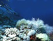 The
diving sites in Anilao are mostly gentle slopes with
coral patches that go with some
huge rock formations and small walls. All the reefs
are excellent for sea stars, sea cucumbers, and other
colorful fishes. Pelagic creatures can be found around
the offshore reefs.
The
diving sites in Anilao are mostly gentle slopes with
coral patches that go with some
huge rock formations and small walls. All the reefs
are excellent for sea stars, sea cucumbers, and other
colorful fishes. Pelagic creatures can be found around
the offshore reefs.